This lesson will use students' knowledge of William Penn and their math skills to develop a map of a portion of center city Philadelphia. This will allow students to compare and contrast William Penn’s map of Philadelphia to Philadelphia today. This exercise is designed to get students to learn how to create and utilize a map as well as to think critically in order to understand how Philadelphia has developed in the past 300 years. In addition to visuals and artwork, students will create their own map of Philadelphia as William Penn envisioned it, using fractions and a ruler, so that they can compare their creation to center city Philadelphia today.
Compare and Contrast Maps of Philadelphia
Compare and Contrast Maps of Philadelphia
Essential Questions
What role does analysis have in historical construction?
Objectives
Student will be able to:
- See the progress of Philadelphia as a city from a small plan by William Penn to today.
- Use and understand maps as well as how to create their own map using a ruler and fractions.
Primary Sources
Other Materials
- Map of London from 1700’s to compare Philadelphia grid system.
- Map of Present day Philadelphia to compare.
-Map of Philadelphia Worksheet
- Ruler, Pencil, Paper.
Suggested Instructional Procedures
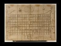
1. Begin by reviewing the information previously learned about William Penn and how Pennsylvania was founded. Remember to highlight how innovative Penn was by making Philadelphia a “grid system.” In order to illustrate the innovation of the grid system, show the students a map of London from the 17th century so they can understand how it would be much more difficult to map since the streets are not in a grid system.
2. Introduce students to the original maps of Philadelphia. Point out that the lines running north and south are numbered, and the lines running east and west are named after trees. After discussing the map as a class, have the students draw a map of their own (using rulers for clarity) so they can write the names of the streets as they were in colonial times. You can leave the map on the front board while students complete their own maps so they have a better understanding of what the finished product should look like.
3. Instructions to make the map: (Please note this is only of the city center and it does not include Cedar or South Street. It is meant to act as a guide for students to understand map making as well as how William Penn laid out the city grid system.)
a. Make sure each of the students creates their maps with the same dimensions using the How to Create a Map of Philadelphia worksheet as a guide. Depending on level of student, they can create the map individually or in pairs. Teachers should help the students in the beginning by assisting the students in how to find the center of their paper and to create a compass rose in the top right corner. After that students should work individually or in pairs, up to teacher discretion, to finish the map. (It might be best to emphasize that the students need to follow all the instructions and should not skip ahead because the dimensions will not always be the same.)
b. Students will use inches to complete their map. Therefore they need to understand how inches break down into fractions and how to properly use the ruler. (If students are at a higher level, you can incorporate having students switch the fractions to decimals and vice versa.)
4. Once students have completed their map and it is checked for accuracy, they are free to decorate it with landmark, such as parks and buildings. For 5th grade students, you can make the map a challenge by asking them to find the area of the different rectangles using their ruler.
5. After all students have completed their maps, you can compare and contrast their maps to a map of Philadelphia today with the streets labeled. As a class, create a Venn diagram to mark the similarities and differences.
Vocabulary
Compass Rose: A circle showing the principle directions. Usually printed on a map or chart.
Fraction: A part of a whole.
Horizontal: Parallel to the horizon. A line that moves right to left or left to right.
Intersect: Where two lines meet at a cross point.
Vertical: Moving straight up and down.

Plans in this Unit
Grade Level
Grade School
Duration
40 minutes
Standards/Eligible Content
M3.A.1.2.2
M3-5.B.2.1.1
Attention Teachers!
Let us know how you used this plan and be featured on our site! Submit your story here.